|
I made this web page of hiking trails in Southern
California. I got a couple 'likes' for it and I don't know how
people even found the page so maybe I have something. I used
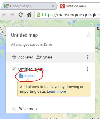
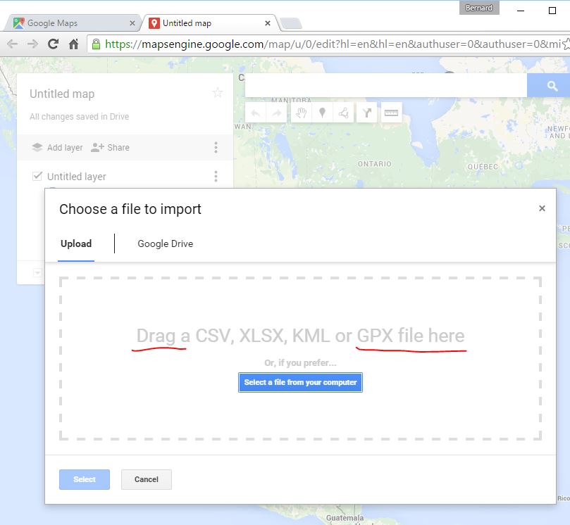
alltrails.com to make the GPS files (.gpx) of the trails then imported
them into Google Maps. I use a hiking GPS but I think you can use
a smart phone and navigate just by clicking on the Google Maps version.
I've got two views on hiking. It sure seems like the people at the
pool appear to be in much better shape but hiking uses muscles that you
don't normally use which I believe is why you're sore the next day.
The reason I made the webpage is that I searched the Internet for the .gpx
files or hikes I wanted to try. The few sites that had them were
actual .gpx recordings. Who wants to track a pervious track
including each place they went to the bathroom? Seems like it's
impossible to find the information I put on this page. Even the
group hikes I've been on seem to break up between the slower and faster
hikers. Seems like it'd be prudent for the ones bringing up the
rear to have that as a backup navigation. See the following
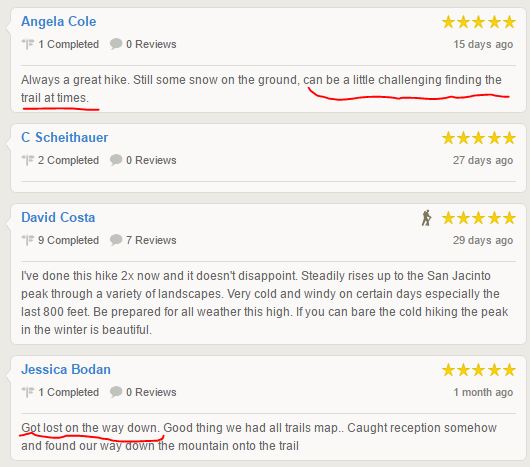
comments for the Tram to Jacinto hike regarding losing the trail.
I've done that when I was already chasing daylight and it was almost a
disaster.
Also see
alltrails.com. They imply that they're associated with
National Geographic but I'm not sure if that's the case. Their Pro
version runs about $50/year but they sometimes have a special for
$30/year. The Pro allows you to download .gpx files of their
trails and print maps and also has a feature to plot your own maps and I
assume convert them to .gpx.
How
to use the iPhone as the Best Backpacking GPS - I like the $5
MotionX app for my iPhone better than I like the $300 Garmin hiking GPS
that I have. You can expand the screen and tell if you're five steps off
course. The problem is that I don't know if I'd trust the iPhone GPS
chip in places where my life depended on it. That said the iPhone is a
good backup. See the bottom of this page for how to import .gpx tracks
into MotionX. Alltrails.com generates the .gpx's but they charge
$50 per year for the membership but they usually have a discount for $30
per year. I can whip them out in five minutes if anyone wants one. I
also have the Anker portable charger
that they show. It will charge your iPhone, headlamp, GPS, etc. It's
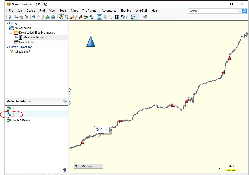
a life saver. Regarding the Alltrails .gpx file, you need to
convert them to tracks .gpx file with software such as
Garmin Basecamp. See the procedure below. Also, select
the track and right click and rename it. Then go file > export.
-
Does MotionX-GPS require a cellular network? -
"The iPhone 5, 4S, 4, 3GS and 3G use an
A-GPS (Assisted-GPS) chipset which uses cell tower triangulation to
speed up GPS signal acquisition. Cellular coverage is not needed to
acquire a signal, however the signal acquisition will be much
quicker if you have data coverage ... Without data services, it can
take 15 minutes or longer to acquire a signal. This is simply
because it takes longer to determine which satellites to use out of
the 31 available around the world. With data services, it typically
takes under a minute, but it can take up to 5 minutes" -
I've got the 5S. I think that means I'm OK.
-
MotionX-GPS FAQs
San Diego park rangers name best Instagram hikes - 10News, 2/13/20
Click on the first link to download the .gpx file.
Click on the miles link for a description of the hike:
Top 4 Family-Friendly Hikes in San Diego County - NBC San Diego,
2/19/18
Cedar Creek Falls Trail (4.8 miles R/T)
Cedar Creeks Fall Trailhead,
15519 Thornbush Road, Ramona, CA /
.pdf map /
.gpx r/t
download /
Channel 7 News /
Permit required (760)788-0250 (use this link for online permit)
Three Sisters Falls Trail (4.5 miles R/T)
Three Sisters Waterfalls
Trails trailhead, Boulder Creek Rd, Santa Ysabel, CA 92070 /
.pdf map /
.gpx track
out/in /
Channel 7 News /
Ranger website
Black Mountain (4.0
miles R/T)
Google map to trailhead, 9711 Oviedo Way, San
Diego, CA /
.pdf map /
.gpx
download
Granite Mountain
Hotshots trail (7.2
miles R/T)
Google map to trailhead, Granite Mountain Hotshots
Memorial State Park /
.pdf map /
.gpx
download
Wind Caves and
Elephant Knees (12.5 miles R/T unless you can get closer than the
campground with a SUV)
Google map to Fish Creek Primitive Campground,
Borrego Springs, CA /
.pdf map /
.gpx out /
Google map of the trail
Hot Springs Mountain (9.5
miles R/T)
Google map to trailhead, Los Coyotes Campground /
.pdf map /
.gpx out /
Google map of the trail
Mushroom House (6.26
miles R/T)
Google Map to trailhead (Callan Road and North Torrey Pines Place, San
Diego, CA, 92121) / .pdf map
/ .gpx out download
Boden Canyon and Orosco
Ridge Trail
Google map to trailhead
/ .pdf map /
.gpx download
Sitton Peak (9.74 miles
R/T. I added .2 R/T to the .gpx because it starts a tenth mile
into the trail)
Google map to trailhead (Ortega Oaks Candy Store, 34040 Ortega Hwy ·
Lake Elsinore, CA) / .pdf map of the trail
/ .gpx out /
.gpx return
Laguna Meadow Loop (5.88 mile loop)
Google map to trailhead (12031 Sunrise Highway, Mount Laguna, CA, 91948)
/ .pdf map /
.gpx download
San Jacinto Peak via Devil's Slide Trail
(Humber Park)
San Jacinto via Devil's Slide (Humber Park) r/t /
Devil's Slide to Jacinto .pdf map /
Humber Park to Jacinto .gpx /
Jacinto to Humber Park .gpx /
Google Maps (http://bit.ly/2eh6zj5) / Google Maps
.pdf
/ Map to Idyllwild Ranger
Station / Map to Humber
Park, 24400 Fern Valley Rd, Idyllwild-Pine Cove, CA 92549
/
Requires pass for this trail (.pdf)
/
San Jacinto Peak Weather
San Jacinto Peak via Tram
San
Jacinto via tram r/t map link /
Tram Jacinto .pdf map / Tram to Jacinto
.gpx / Jacinto to Tram .gpx /
MotionX Tram to Jacinto /
MotionX Jacinto to Tram /
Google maps (http://bit.ly/2ehSMFh) / Google .pdf /
Long Valley
webcam / You have to fill out a pass at the ranger station about 0.4
miles from the top of the tram. It's along the trail /
San Jacinto Peak Weather /SoCal
Hiker summary
San Jacinto Peak via Marion
San Jacinto
via Marion r/t map link / Marion to
Jacinto .pdf map / Marion to Jacinto .gpx
/ Jacinto to Marion .gpx /
Map to Idyllwild Ranger
Station, 54270 Pine Crest Ave, Idyllwild, CA 92549 (need to fill out a
pass, has after hour counter) /
Map to Marion Campground /
Google maps Marion to Jacinto /
Google .pdf map of Marion to Jacinto /
San Jacinto Peak Weather
Suicide Rock
Map to Idyllwild Ranger
Station, 54270 Pine Crest Ave, Idyllwild, CA 92549 (need to fill out a
pass, has after hour counter) / Google
map to Deer Spring Trailhead / .pdf map
trailhead to Suicide Rock / .gpx
out / .gpx back
Mt San Jacinto via Fuller Ridge Trail
Map to Idyllwild Ranger
Station, 54270 Pine Crest Ave, Idyllwild, CA 92549 (need to fill out a
pass, has after hour counter) /
Google maps ranger station to Fuller Ridge Trailhead (Black Mountain
Truck Trail) /
AllTrails.com link /
AllTrails.com info link / Fuller to
Jacinto .gpx / Jacinto to Fuller .gpx
/ AllTrails.com .pdf map /
Google maps Fuller to Jacinto trail /
San Jacinto Peak Weather
Mt. Baldy
Trailhead Google map /
All Trails Map
Link / All Trails .pdf map /
Mt. Baldy Loop .gpx /
Mt. Baldy loop on Google Maps in satellite view
Borrego Springs - Palm Canyon to South Fork
Falls (2.8 miles R/T)
Google Map to the trail head
/
Borrego Springs
R/T / Borrego Springs .pdf /
Borrego Springs out .gpx /
Borrego Springs return .gpx
/
All Trails Hike description /
All Trails out/in .gpx
Borrego Springs - Maidenhair Falls via
Hellhole Canyon Trail (5.1 miles R/T)
Google Map to Hellhole Creek
Trail Head / All Trails
.pdf map / .gpx download /
All Trails trail description
Borrego Springs -
Villager Peak (6.99 out + 7.29 back = 14.28 miles R/T)
Google map to trailhead /
.gpx out download /
.gpx return download /
AllTrails .pdf map /
AllTrails map link for Villager Peak Loop
San Gorgonio via Vivian Creek Trail
Google map to Vivian Creek
Trailhead, Forest Falls Rd., San Bernardino, CA /
AllTrails map link / AllTrails .pdf
map / Vivian trailhead to Gorgonio .gpx
download / Gorgonio to Vivian .gpx
download /
San Gorgonio Wilderness Association
website / Mill Creek
Ranger Station, 34701 Mill Creek Rd, Mentone, CA 92359 (909) 382-2882
/
Vivian to Gorgonio on Google maps /
Forecast /
Permit required, min. 5 business days to process
Los Penasquitos Canyon map:
Los Penasquitos Canyon map (.pdf)
/ .gpx
/ link
Torrey Pines
Google Map to
parking
/ .gpx download /
.pdf map /
All
Trails map link / .gpx from
parking to trail to beach (download) /
Link map
from parking to trail to beach /
.pdf map from parking to trail to
beach /
AllTrails
link to Parking to trail to Del Mar Loop (5.3 miles) /
.gpx download for Parking
to trail to Del Mar loop /
.pdf for Parking to
Trail to Del Mar loop /
Torrey Pines tide schedule
Kelly Ditch Trail To Lake Cuyamaca (10.6 miles
R/T)
Google Map to
parking /
AllTrails map link /
.pdf link /
.gpx download
Mt. Woodson then Potato Chip Rock (another
quarter mile) from Highway 67 (4.12 miles RT, 1175 elevation gain)
Google Map to
parking /
AllTrails map link for AllTrails members /
.pdf map /
.gpx Hwy 67 to Potato
Chip Rock download /
.gpx Potato Chip Rock
to Hwy 67 download /
Alltrails link for non-members /
Google Map from Parking to
Potato Chip Rock
Bridge to Nowhere (9.28 miles R/T)
Google map to trailhead /
Alltrails map for members / .pdf
map / .gpx out /
.gpx return /
Stonewall Peak Loop, Cuyamacs (3.82 miles R/T)
Google map to trailhead /
Paso Picacho to
Stonewall Peak.gpx /
Stonewall Peak to
Paso Picacho.gpx / Stonewall Peak
loop .pdf map / Paso
Picacho to Stonewall Peak on Google Maps
Others (Some of my earlier work but may not be
accurate):
The San Clemente Beach Trail by SoCall Hiker
Chiquito Falls
.pdf
.gpx
Every
Trails take
SoCal
Hiker's take - I put those last two because they don't look like
what I came up with.
Espola Woodson
out in
map topo
All Trail generated .gpx
Actual .gpx
Mount Woodson
Koegel Loop .gpx download (generated via alltrails.com software) (actual)
-
Mount Woodson Koegel Loop on Google Maps (actual) -
Mount Woodson
Koegel Loop on AllTrails.com - map (.pdf)
Black
Mountain Trail .gpx -
3.6 miles
Ontario - Bighorn .gpx
file -
Ontario - Bighorn Trail Map -
Map to Trailhead Parking (7650
Ice House Canyon Road, Mt Baldy, CA) -
Mt Baldy,
CA 91759 weather Ontario
Peak Weather
Cucamonga Peak via Icehouse Canyon
.gpx -
11.6 miles (map to get to
Icehouse Canyon Trailhead, Ice House Canyon Road, Mount Baldy, CA 91759)
Etiwanda Peak
.gpx
- 10 miles for
route 2 (map to get to
Icehouse Canyon Trailhead, Ice House Canyon Road, Mount Baldy, CA 91759)
Los Penasquitos Canyon Trail
.gpx
-
6.1 miles
Mt. San Antonio (Mt Baldy) Loop
.gpx -
10.2 miles
Potato Chip
Rock Mt. Woodson Trail .gpx -
8 miles
San Clemente Canyon Trail
.gpx
(Marian Bear Natural Memorial Park) -
6 miles
San Gorgonio via
Vivian Creek .gpx -
17.3 miles
San Gorgonio via Fish Creek
.gpx
- 18.4 miles
San Jacinto Peak
(the easy way) .gpx
San Jacinto
Peak from The Tramway .gpx -
9.94 miles -
View via Google Earth -
View in Google Maps
Mt San Jacinto via the
Palm Springs Aerial Tram .gpx -
11 miles
Marion
Trailhead to Jacinto Peak .gpx -
Jacinto Peak to Marion
Trailhead .gpx - Marion
Trailhead to Jacinto Peak round trip .gpx -
11.4 miles -
Marion to Jacinto Peak on Google Maps -
Marion to Jacinto map (.pdf) -
Marion to Jacinto .kmz (for Google Earth) -
Map
to ranger station (54270 Pine Crest, Idyllwild, CA 92549) -
Ranger station to Marion
Mountain Campground Road, Idyllwild, CA -
92549 wx
-
San Jacinto Peak Weather
Garmin
Basecamp software
BirdsEye TOPO, U.S. and Canada
Import
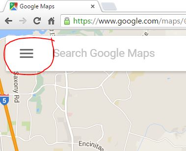
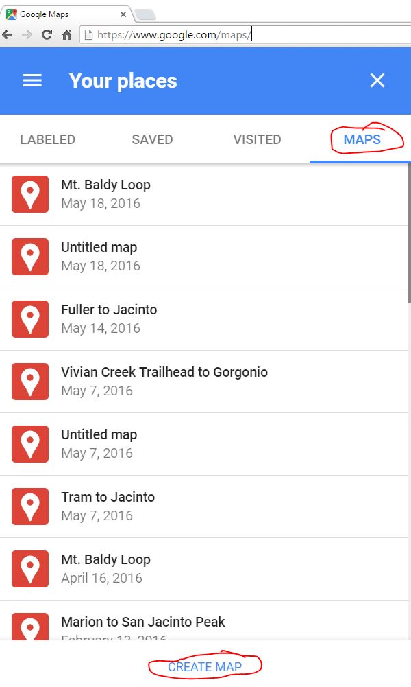
.gpx to Google maps
13710
Los Angeles Hiking Trails website
Procedure to import into the MotionX iPhone app:
-
Click on the file such as "Black Mountain". Save that file on your computer.
It should have the .gpx extension.
-
Send an email to gpsimport@motionx.com with {name}.gpx attached. They will
automatically generate an email back with a link. Click on that link with your
iPhone and it will import it into MotionX. See
http://support.motionx.com/motionx-gps/importing-waypoints-or-tracks/.
Note that in MotionX it will assign a name such as "Track*". It really makes it
confusing. Plus I'm not sure where it gets the date from so don't get confused
if it's out of order.
Hiking Supplies (I read a lot of reviews to find
these):
-
Strava Running and Cycling GPS app
-
Quiksilver Men's Bushmaster Hat, Khaki, Large/X-Large

- Timberland Men's Chocorua Trail
Gore-Tex Mid Hiking Boot (I'd buy a half size larger than what you
usually take)
- Darn Tough Vermont Men's Merino
Wool Boot Full Cushion Socks
- Thorlo Men's Hiker

- Thorlo Unisex Wool/Thorlon Thick Cushion Hiking Sock

-
Camber 305 Max-Weight Heavyweight Long Sleeve T-Shirt - It's the
beefiest long sleeve t-shirt I could find (8-ounces)
-
Camber 301 Max-Weight Heavyweight T-Shirt - USA Made
-
ZnO Long Sleeve T-Shirt at Coolibar - They're made with
bamboo cotton.
- Carhartt Force Workwear Cotton Long Sleeve Shirt Men at Amazon.com
 - 5.75 ounce, 65 percent cotton/35 percent polyester plaited jersey
knit
- 5.75 ounce, 65 percent cotton/35 percent polyester plaited jersey
knit
- Carhartt Men's Workwear Pocket Long Sleeve T-Shirt Midweight Jersey Original Fit at Amazon.com
 - 6.75 ounce. That only one I've see better is the 8 ounce
cottom above.
- 6.75 ounce. That only one I've see better is the 8 ounce
cottom above.
- Dickies Men's Long Sleeve Heavyweight Crew Neck
at Amazon.com
 - It's also 6.75 ounce cotton. You need to got to
their website to find that out.
- It's also 6.75 ounce cotton. You need to got to
their website to find that out.
-
Beach Comber Hat at Coolibar
- Planters Trail Mix, Fruit &
Nut, 2-oz. Bags (Count of 72)
- Black Diamond Ultra Mountain
Carbon Trekking Pole -
Click here to determine the length
- Outdoor Research Chroma Full
Sun Gloves
- La Roche-Posay Anthelios SPF 50
Mineral Ultra-Light Sunscreen Fluid Tinted
- Columbia Bora Bora Booney II
Sun Hats
- Camelbak Products Men's
Fourteener 24 Hydration Pack
- Carhartt Men's Loose Fit Canvas Carpenter Five Pocket at Amazon.com

- Sawyer Products Mini Water
Filtration System
-
Anker 2nd Gen Astro 6400 ($20) cell
phone charger at Amazon.com (see review below). Also see Anker PowerCore+ 13400 (Recharges 2X Faster than Normal Portable Chargers) Premium Aluminum 13400mAh External Battery Charger with Leading 4.8A Output for iPhone, iPad, Samsung and More (Black)
 . .
-
Headlamp Flashlight - USB Rechargeable 280 Lumens Cree Led, Super Bright, Waterproof, Lightweight & Comfortable, 100h Battery Life, Best for Running, Caving, Hiking, Camping, Kids
 - Note: I think the Anker 2nd Gen
Astro charger will charge this in addition to your cell phone.
- Note: I think the Anker 2nd Gen
Astro charger will charge this in addition to your cell phone.
- 3M STERI STRIP SKIN CLOSURES 1/8'' X 3'' 10 PKG/5
 - These things are a life saver and should be in every backpack.
- Sea to Summit Mosquito Head Net
at Amazon.com

- Light My Fire Titanium Spork

- Sea To Summit Delta Bowl with Lid Grey, 27 fl. oz.

- Ziploc Twist 'N Loc Containers, Small 2 Cup, 3 Containers & 3 Lids (Pack of 2)

- TAC Force TF-705RD Assisted Opening Tactical Folding Knife, Black Half-Serrated Blade, Red Handle, 4-1/2-Inch Closed

- Adventure Medical Kits SOL Emergency Bivvy, 84" X 36"

- Vastar® Premium Quality 4 in 1 Multiple USB Charging Cable Adapter Connector with 8 Pin Lighting / 30 Pin / Micro USB / Mini USB Ports for iPhone 6s, 6s Plus, iPhone 6, 6 Plus, 5 / 5S / 5C, 4S 4, iPad 4 3 2, iPad Air, iPad Mini, iPod touch 5th Gen, iPod Nano 7th Gen, Galaxy S2, S3, S4, and More

- Garmin GPSMAP 64st, TOPO U.S. 100K with High-Sensitivity GPS and GLONASS Receiver

- Garmin GPSMAP 62 Handheld GPS Navigator

- Garmin GLO Portable GPS and
GLONASS Receiver with Vehicle Power Cable - Instead of buying
the Gamin Handheld, this might be a better option along with the
MotionX app for the iPhone. The MotionX app is a much better
interface. The Garmin Handheld reminds me of the antiquated
Apple II computers from the '80's. Without this attachment,
the iPhone doesn't have the GPS reception in areas where you need
it. Also see SkyPro XGPS160 GPS Receiver
 and Bad Elf 2200 GPS Pro (Black/silver)
 which looks like Garmin's competitors.
-
Garmin Basecamp software
-
BirdsEye TOPO, U.S. and Canada
-
Topo North America
- http://www.meetup.com - To
find hiking groups
-
Strava's safety 'Beacon' shows friends where you're training - A
good Garmin hiking GPS will do the same thing and it's included in
the one time price of the product. Plus you're not limited to three
people. I've posted the link on Facebook one time when I went to San
Jacinto. The problem you run into is that it eats the battery life.
You get about 10 hours and when you change the battery it drops
connection. The solution is to have rechargeable batteries in the
GPS and keep it connected to a portable USB charger (part of the
time at least). See:
http://amzn.to/2ao8haD
The best portable USB battery pack for daily use - engadget.com,
6/26/15 - "The
Anker 2nd Gen Astro 6400 ($20) is the best pocket-size
USB battery for most people, because it comes closest to hitting the
sweet spot for price, charging speed, capacity, and portability. Thanks
to its smart-charging circuitry, it works well with any current
smartphone, and it should be able to handle new models that come out in
the next couple of years, too. It's sturdy enough for the daily grind
and small enough for a pair of relaxed-fit jeans"
GPS Visualizer:
Convert GPS files to plain text or GPX - Neat website to convert
Google Maps into .gpx files for things like hiking with MotionX on your
iPhone or iPad. Cut and paste the Google Maps URL into
this website (the
URL field) and it will generate the gpx file. To import a .gpx file into
MotionX on your iPhone, cut and paste the code into notepad. Save the
file to {name}.txt. Using File Explorer, rename the file to {name}.gpx.
Send an email to gpsimport@motionx.com with {name}.gpx attached. They
will automatically generate an email back with a link. Click on that
link with your iPhone and it will import it into MotionX. See
http://support.motionx.com/motionx-gps/importing-waypoints-or-tracks/
- Here's an example to a hill near my home. Google Maps plotted
the trial (you have to select "Hiking"). You also need to select
"Google Hybrid" for the maps in MotionX.


How To Make The Business
Bucket - YouTube
Converting an Alltrails.com
.gpx to a track .gpx using Garmin Basecamp software:
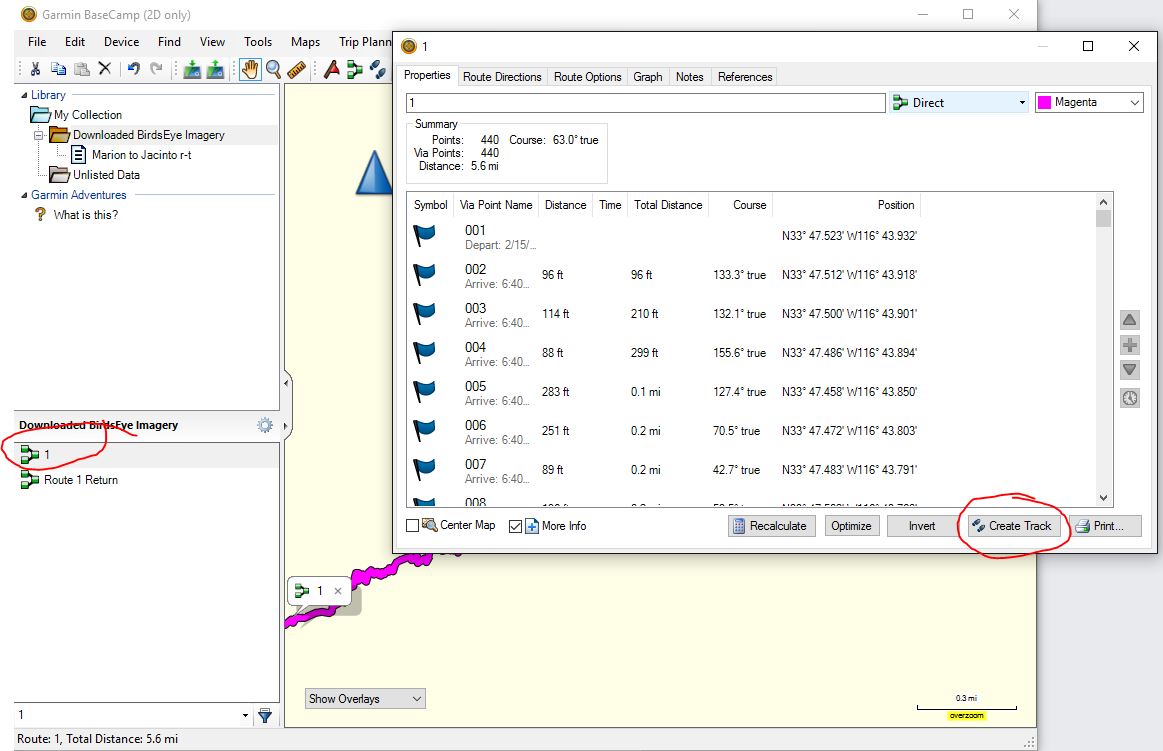
Right click the track and rename it then go "File >
Export".
Acetaminophen: A viable alternative for preventing acute mountain
sickness - Science Daily, 6/19/17 - "They
found almost no difference in the performance of both drugs, suggesting
that acetaminophen may be another effective prophylactic treatment for
AMS"
|